A boulder almost completely buried by sand at that spot soon became a favorite landmark. Over the years, “Whale Rock” emerged from an eroding sand dune, presenting a different view throughout the seasons and slowly appearing farther and farther from the sandy shore. Today that large rock is still visible, but lies more than 1,800 feet from the beach, marking the past location of the shore and dunes.
Beaches are fragile, dynamic environments that respond to wind, currents, waves, tides, changing seasons, and manmade shoreline changes, with either loss of sand (erosion), build-up of sand (accretion), or both. Beaches are also landscapes on the “front lines” of climate change-driven sea level rise and storm surge. While it can be difficult to distinguish between natural shifts and the impacts of climate change, data and mapping show us where these impacts are resulting in a net loss, including at Crane.
In fact, Crane Beach has narrowed by five feet per year since the 1950s, for a total loss of 112 acres—the equivalent of 84 football fields—and has lost approximately 2,000 feet in length since 1995. On Martha’s Vineyard, Trustees-managed Norton Point Beach lost 74 acres in the 97-year period between 1897 and 1994, but 93 acres (25% more), in the 24-year period between 1994 and 2018.
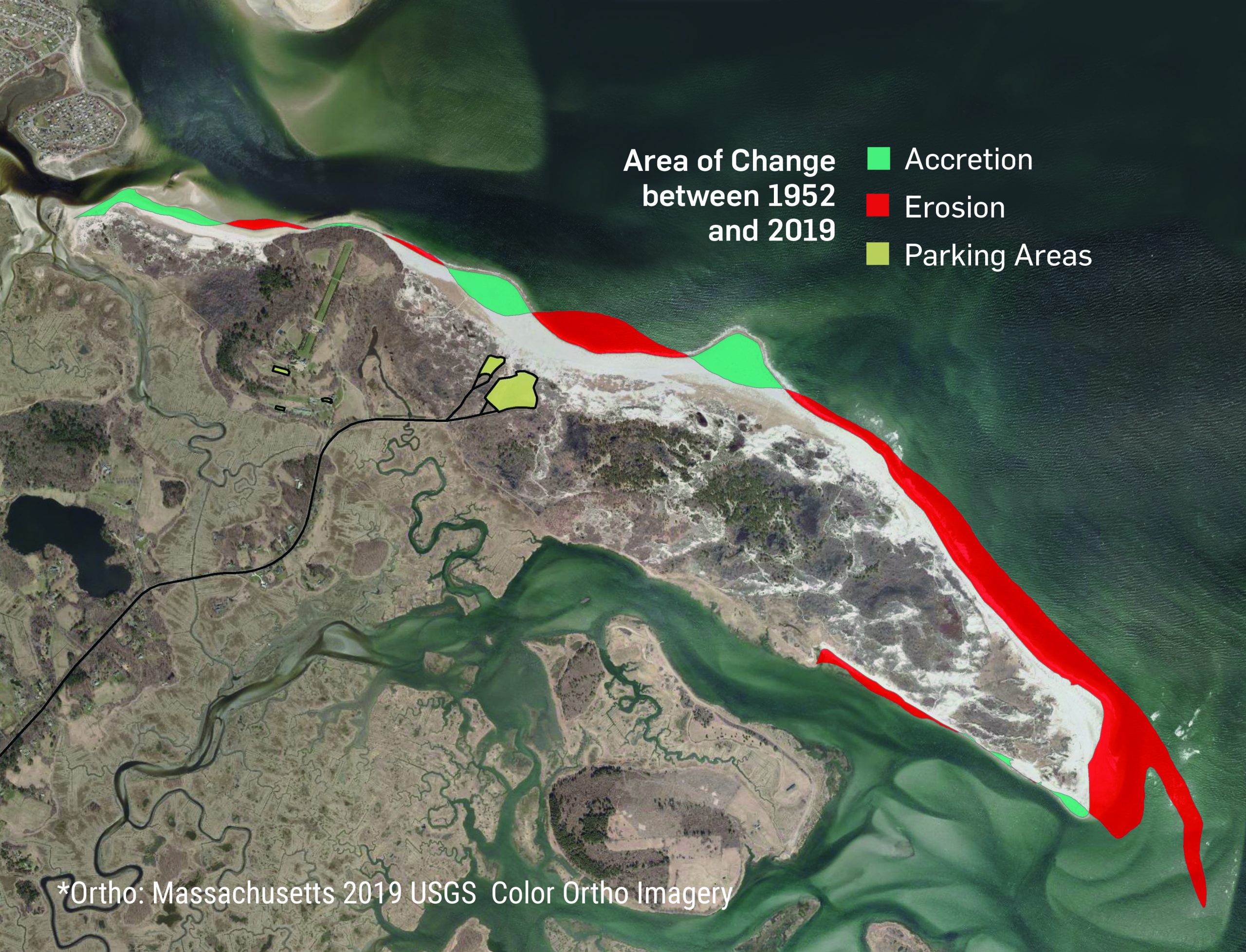
ABOVE: The eastern tip of Trustees-owned Crane Beach has narrowed by 5 feet per year since the 1950s for a total loss of 112 acres, and has lost about 2,000 feet in length since 1995 (thetrustees.org/SOC).
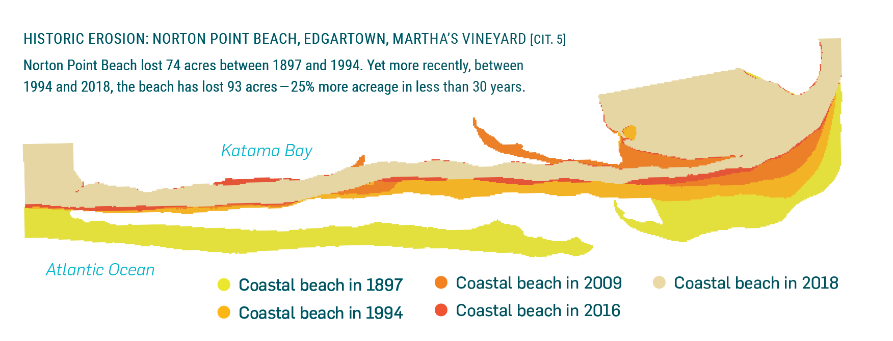
ABOVE: Norton Point Beach lost 74 acres between 1897 and 1994. Yet more recently, between 1994 and 2018, the beach lost 93 acres - 25% more acreage in less than 30 years (thetrustees.org/SOC).
Over the weekend, the winter nor’easter caused erosion at several Trustees coastal properties, particularly on Nantucket and Martha’s Vineyard. On Nantucket, the coastal dune along the entire east beach of Coskata-Coatue Wildlife Refuge (CCWR) was significantly scoured back by powerful waves and littered with debris, in addition to significant wash-over experienced at the narrow stretch of beach known as the Galls. CCWR will remain closed until cleanup is complete and conditions are safe. On Martha’s Vineyard Trustees properties, snowfall amounts made OSV trails impassible and stewardship teams began assessing beachfronts for impacts and damage, as access allowed. (For CCWR access updates call 508.228.5646 #2, and for MV access updates call 508.627.8390).
No significant damage or impacts were observed at Crane Beach and the moveable gatehouse, which was raised 12” in preparation ahead of the storm, will be lowered back to ground level in the coming week.
As the largest private owner of protected coastline in the state, with 120 miles under its care, The Trustees has enacted a forward-looking coastal strategy to prepare our most vulnerable sites for a turbulent future, recognizing that the accelerating potential for coastal storms such as this, as well as sea level rise, flooding, and erosion could impact the preservation and enjoyment of the properties and habitats we have been charged with protecting. The effort launched by engaging Woods Hole Group (WHG) to conduct a Coastal Vulnerability Assessment (CVA) in 2017, for a data-driven roadmap of how—and where—to best protect and adapt our special places, so they may be enjoyed by generations to come.
As a result, adaptation and resilience projects are underway at coastal properties up and down the coast, including a sediment study in Essex Bay in partnership with Boston University; a project with The Town of Ipswich to raise a half-mile stretch of the access road to Crane Beach, Argilla Road, bolstering its resilience to increased flooding events; an innovative salt marsh restoration effort, pioneering a nature-based technique at Old Town Hill in Newbury; and two beach resiliency projects on Martha’s Vineyard and Nantucket, to model adaptations and interventions to coastal erosion and flooding.
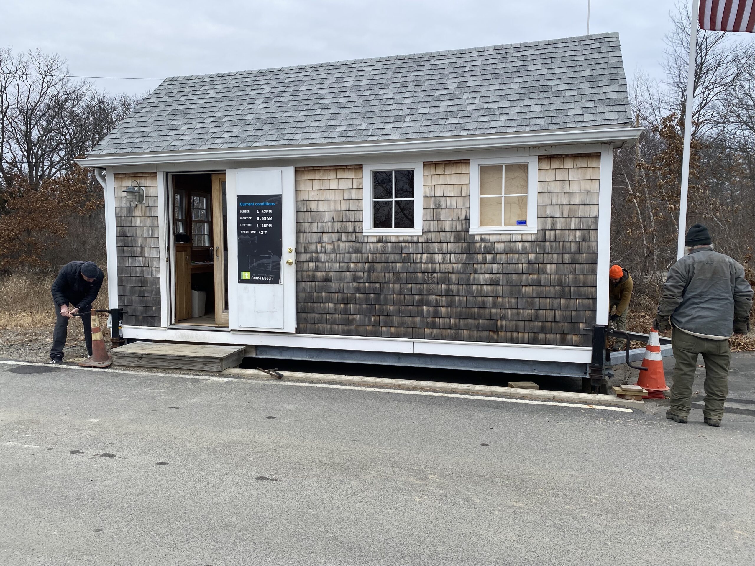
ABOVE: The moveable gatehouse at Crane Beach is raised 12" ahead of the January 2022 nor'easter.
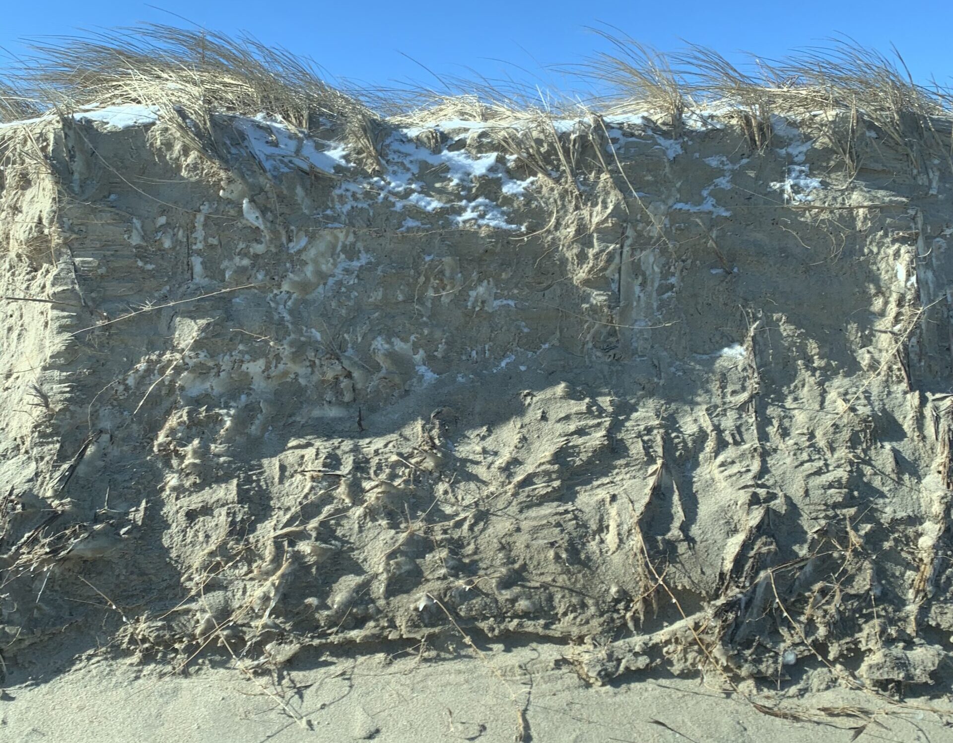
ABOVE: An up-close look at the scouring of the east beach dunes on Coskata Coatue, following the winter nor'easter of January 2022.
An annual State of the Coast report was launched in 2020, highlighting sea level rise and storm surge impacts impacting or projected to impact coastal zone communities in Massachusetts, spotlighting current strategies, and proposing future opportunities. Designed to be a comprehensive resource that can engage, inform, and spark dialogue and action, the report pinpoints climate-based threats and highlights solutions for adaptation and resilience.
“We have a responsibility to innovate, to be forward-thinking in our stewardship of beloved properties including beaches, islands, 2,300 acres of salt marsh, rocky coasts, and dunes,” says Trustees Director of Coast and Natural Resources Cynthia Dittbrenner. “Together with our visitors, volunteers, communities and partners, we can continue to care for these coastal areas now and in the future—to protect their fragile ecosystems, to be more resilient, and to keep them open and accessible to the public, for all to enjoy.”