The project comes after the Massachusetts Office of Coastal Zone Management (CZM) awarded a $240,674 grant to the Town of Edgartown in August, to restore the primary coastal dune on South Beach and Norton Point Beach, relocate one of three bathhouses 50 feet inland, and remove an asphalt lot. The Trustees and Dukes County are project partners in this restoration work, which will see the current OSV trail moved further inland, away from its current vulnerable position.
Ultimately the project aims to strengthen the resiliency of the coastal landscape, while also protecting public access.
“This dune restoration will take place along a vulnerable stretch of beach, where repeated overwash events from tides and storms have completely eroded the primary dune,” noted Tom O’Shea, Trustees Managing Director of Resources and Planning. “By restoring the primary dune we can help to protect the vital habitat on the beach and behind it, and maintain public access to this beloved property, which faces accelerating challenges in coming years from the impacts of climate change.”
With 120 miles of coastline in its care, The Trustees is the largest private owner of protected coastline in the state, and is focused on trying new, innovative projects and solutions to help adapt and protect its vulnerable properties. This resiliency project, announced in August, follows publication of The Trustees second annual State of the Coast report, which explores current and future climate change-related risks to Martha’s Vineyard, Nantucket, and the Elizabeth Islands, as well as potential paths forward.
The Trustees’ “State of the Coast” report for Martha’s Vineyard, Nantucket and Gosnold finds that nearly 800 structures worth more than $4.6 billion may be lost by 2050 to erosion. More than 44 miles of roads are also at risk.
— WBUR (@WBUR) August 4, 2021
Norton Point, one of eight reservations the Trustees protect and steward on Martha’s Vineyard, is one of the properties facing the accelerating impacts of climate change, including sea level rise and storm surge. As reported in this year’s State of the Coast, this 2.5-mile barrier beach of sand and dunes has already migrated to the north more than 1,500 feet since 1897— a distance longer than the Empire State Building is tall. But in addition to this shift, the beach lost 74 acres between 1897 and 1994, and 93 acres between 1994 and 2018—25% more acreage in recent years, despite the shorter timespan.
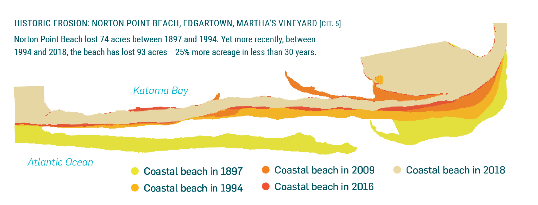
Norton Point Beach lost 74 acres between 1897 and 1994. Yet more recently, between 1994 and 2018, the beach lost 93 acres - 25% more acreage in less than 30 years.
Working with Woods Hole Group to model the reconstructed dune, the project team settled on a 14-foot-high design. The dune will have a gentle slope ratio of 10:1, meaning that for every 10 feet of horizontal distance there is a one-foot vertical decline. The height and slope were selected after conducting analysis and modeling to see what would be most resilient to erosion and storm surge. The dune construction will use native plants and compatible dredge material, sourced from Katama Bay.
“The reconstructed portion will run from the dune break east of the entrance and continue eastward where it will connect to a small dune and onto the larger one,” explains Paul Morrison, Trustees Stewardship Manager for Martha’s Vineyard. “This is first of two phases, and will help to strengthen the dune system, while also protecting access for visitors in the coming season. In the second phase of this project the existing dune in the area behind the gatehouse will be built up, the gatehouse will be relocated, and the new OSV trail will be extended from where it ends in phase one.”
For the first phase, dredging will begin the week of November 8, with sand pumped to the bayside shore of Norton Point east of the gatehouse. Piping will be buried under the sand where it crosses the OSV corridor, with the dredged sand deposited into a 20-foot-wide trench on the outer beach, allowing it to drain—a necessary step before it is loaded into trucks for transport to the project area.
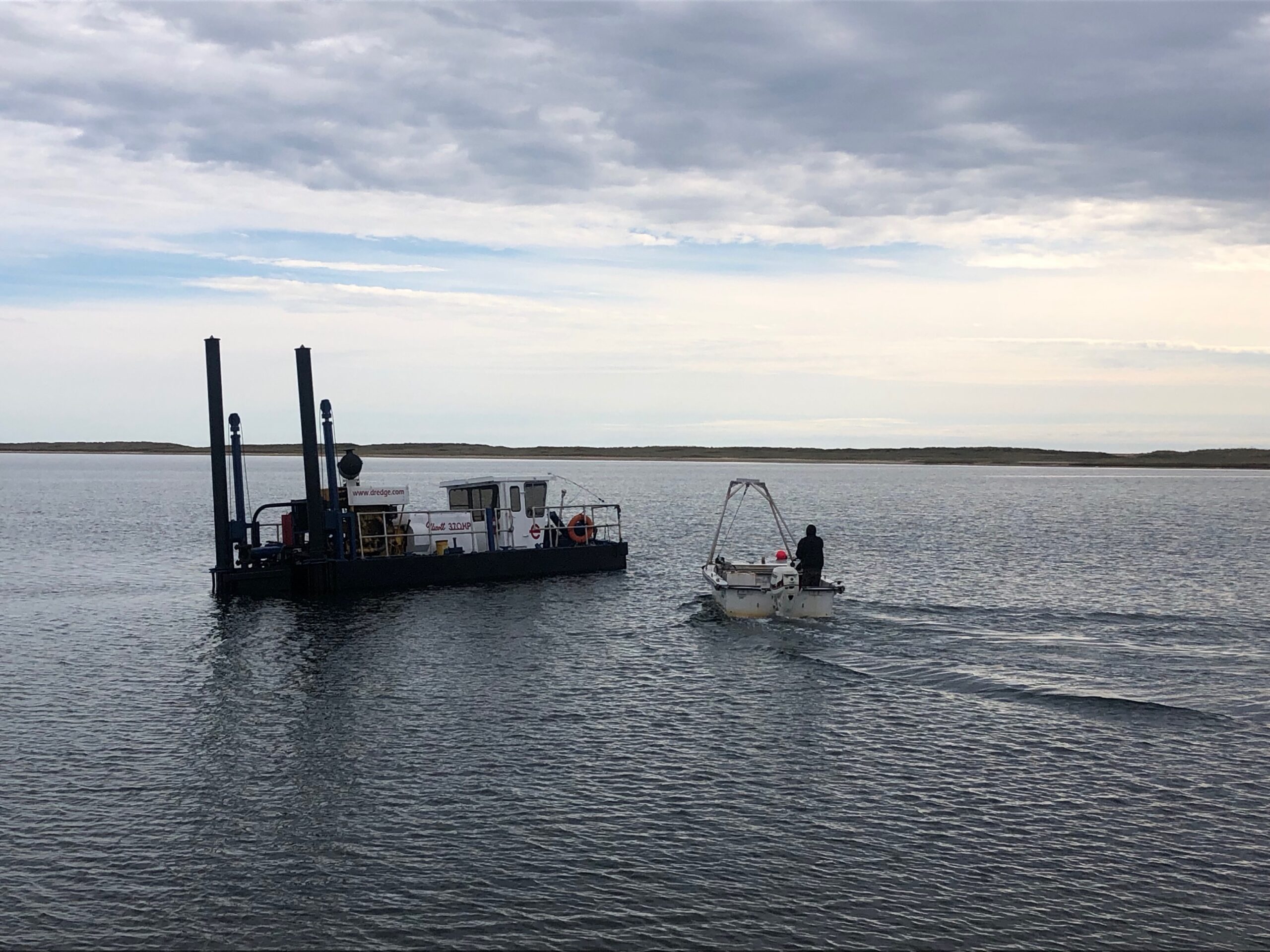
The dredge in Katama Bay (above) will begin pumping sand for a dune restoration project near the entrance of Norton Point Beach.
As the dune is reconstructed, the OSV trail will be relocated northward, away from the ocean and behind the newly built-up dune. Trucking to and grading of sand at the dune construction site is expected to begin the week of November 15 and will likely require a one-month closure of the Norton Point OSV trail. Beachgoers can still access the site on foot during this time, and updates on potential disruption to OSV travel will be provided as soon as the information is available.
Once complete, the reconstructed dune will be a better barrier to storm surge and high tides, protecting the landscape, habitats, roads, and bridge behind it, as well as improving access by providing a buffer between the ocean and the narrow OSV corridor in the area.
“We have seen and will continue to see destructive storm activity impact many of our beaches around the island and up and down the Massachusetts coast,” adds Morrison. “Recently the October Nor’Easter resulted in erosion, flooded OSV trails, and property closures. And it’s not only storms causing disruptions—the Norton Point OSV corridor is also vulnerable to high tides, which can prevent access. Projects such as this dune restoration and OSV trail relocation are vital for the future of our special places, helping them to adapt to the accelerating impacts of climate change.”
On nearby Nantucket, the Trustees and the Nantucket Conservation Foundation (NCF) are using the diverse acreage of Coskata-Coatue Wildlife Refuge (916 acres, Trustees), The Haulover (104 acres, NCF) and Coatue Wildlife Refuge (390 acres, NCF) as a “living laboratory.” Under a three-year adaptation project, the team is working to identify resilient intervention methods and adaptation strategies that can maintain access and sustain habitat and barrier beach integrity. The first phase of the grant-funded project launched in early 2021, to develop a volunteer-led beach profiling monitoring system, design initial beach resiliency concepts to bolster the Refuge’s resilience for the next 10-20 years, establish a partnership for a coastal wave and sediment study, and prepare for potential longer-term projects.
To learn more about The Trustees coastal work, or explore the State of the Coast reports, visit thetrustees.org/coast