A short trail and boardwalk at Charles W. Ward Reservation leads to a quaking (kettlehole) bog. The trail to the bog and the 700-foot boardwalk across the bog are accessible for people on foot or on wheels. Signs are mounted along the boardwalk to provide insights into the many interesting plant species.
If you plan to visit the bog, leave a minimum of half an hour for this out-and-back trail experience.
Each interpretive location is described below, along with additional information.
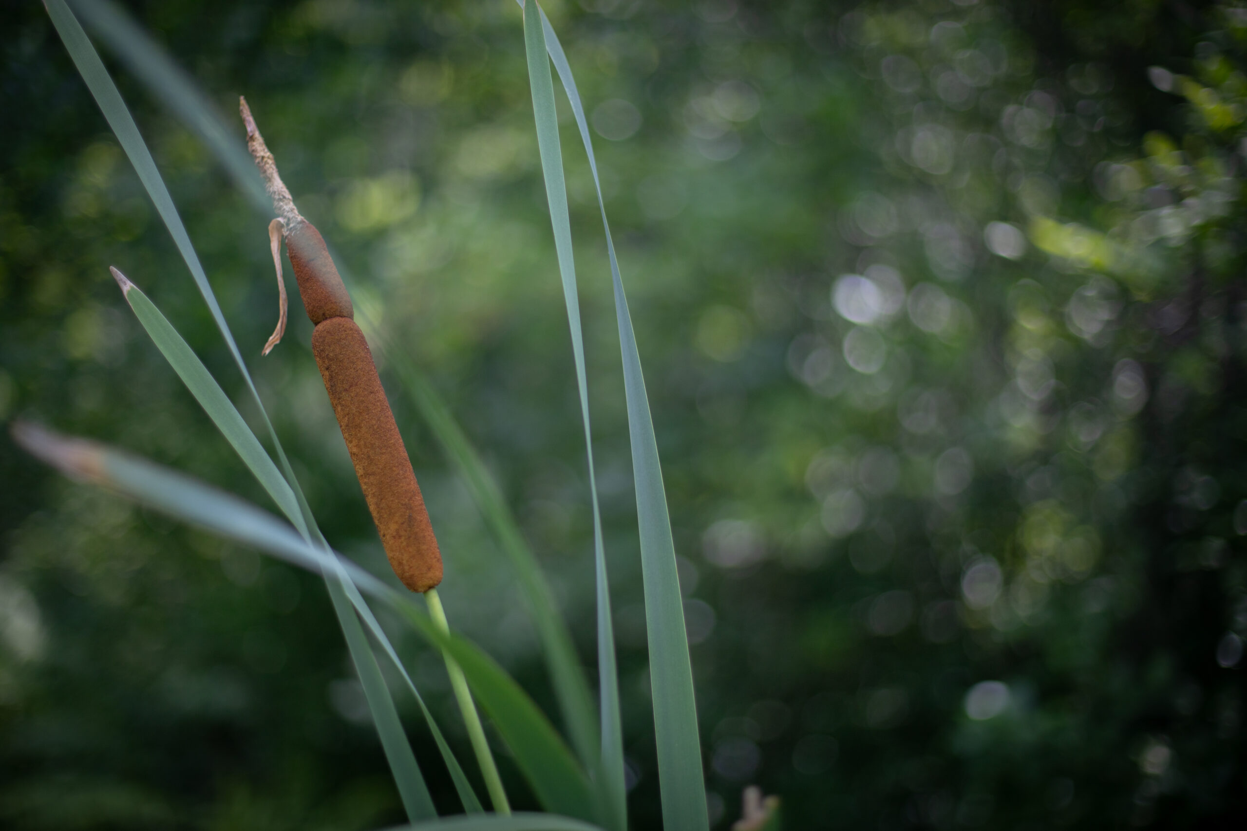
A Cattail at Ward
Sign One: Welcome to Pine Hole Bog
This boardwalk will carry you through a kettlehole level bog—a peatland with little water input or output made of rings of vegetation. Pine Hole Bog is, in fact, an example of a kettlehole level bog that floats over a body of water, resulting in it also being known as a quaking bog.
Once you step onto the boardwalk you leave solid ground behind. Underneath you is a mat of vegetation resting on an accumulation of muck dozens of feet deep.
Sun-Loving Plants
The area in front of the first sign on this trail is maintained by removing woody plants to keep it open for sun-loving bog plants. The plants that remain include some that are found in all sorts of wet locations, such as the river horsetail (Equisetum fluviatile). These plants are very primitive in structure and lack true leaves. Their ancestors grew much larger and their remains contributed to the formation of coal.
Cattails (Typha latifolia) are common inhabitants of open, marshy locations. The cylindrical brown “head” at the top is a dense mass of tiny fruits, each attached to a parachute.
You will also notice several large species of ferns including cinnamon fern (Osmundastrum cinnamomeum), and royal fern (Osmunda regalis). For both species, only the leaves are visible, while the stem and roots grow below the surface of the bog.
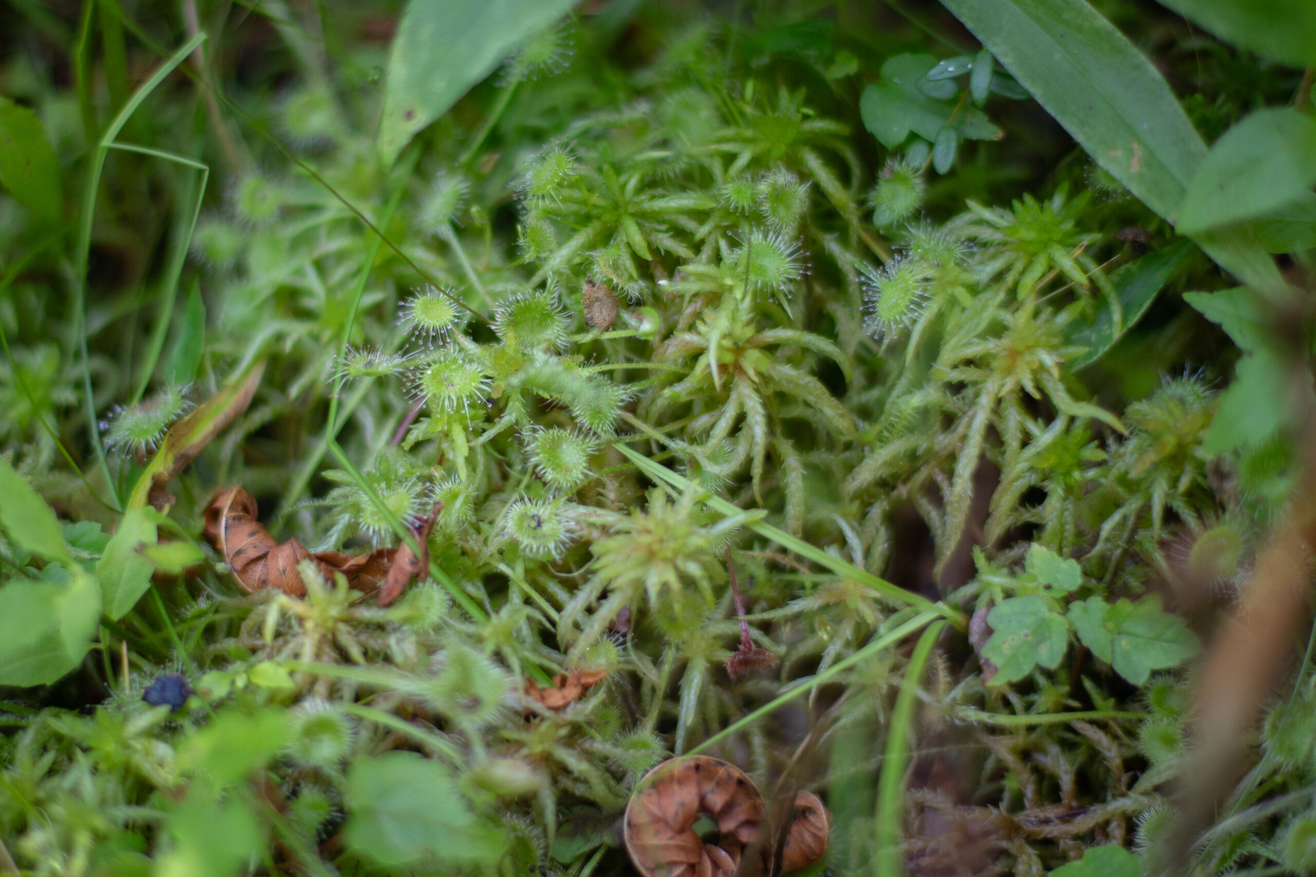
Sundew
Sign Two
In the area around the second sign on the trail, you may notice cranberry (Vaccinium macrocarpon), a low-growing plant with small shiny leaves. This member of the heath family, like many of the heaths, grows primarily in bogs. Its familiar round, red berries are rarely seen in this environment, however.
The grass-like plant with cottony tufts (seen in late summer) is cotton grass (Eriophorum), a member of the sedge family. Sedges, which are not actually grasses, are common inhabitants of wet locations.
If you crouch and look very closely, you will see the tiny insect-eating sundew (Drosera rotundifolia). Sundews have evolved to capture insects since peat is low in nutrients. Insects that land on the glistening, sticky hairs of the sundew’s leaves are often trapped. The hairs fold over the insect’s body, which is then digested by the plant.
As you head deeper into the bog, you enter an area where woody plants grow and are not removed. Many of the shrubs are highbush blueberry (Vaccinium corymbosum), also a member of the heath family. Many of the blueberries we eat have been derived from
this species.
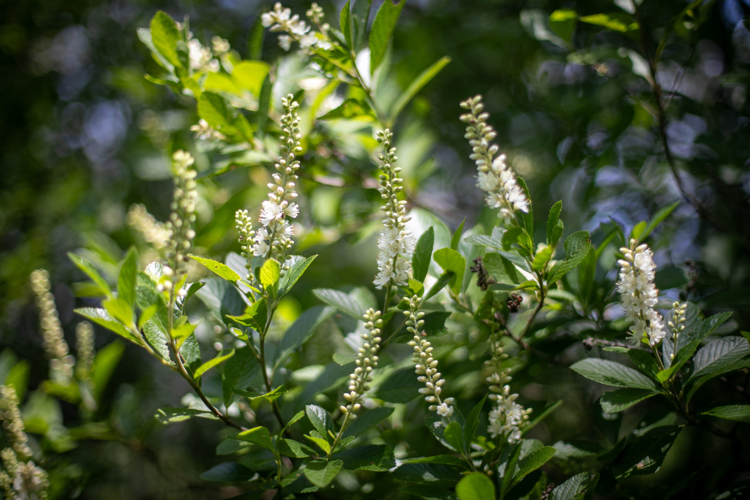
Coast Pepperbush (Clethra alnfolia)
Sign Three
The shrub around you at the third sign on the trail is coast pepperbush (Clethra alnifolia). Its fragrant, sweet-smelling flowers appear in July and August. Pollinators love this plant!
Some of the tall shrubs in this area are swamp azalea (Rhododendron viscosum). Their blossoms, which appear in June, are also very fragrant. This plant is also called the swamp honeysuckle. Swallowtail butterflies are the principal pollinator.
Mixed into the shrub layer are smooth alder (Alnus serrulata). They are relatives of birches and can easily be identified by their fruits, which are cone-like catkins (cylindrical clusters of flowers, often lacking petals).
The small broad-leaved herb so common on either side of the boardwalk as you walk along is the wild calla or water arum (Calla palustris). The plant on the opposite side of the boardwalk behind you is arrow arum (Peltandra virginica), an aquatic plant with leaves shaped like arrowheads that can grow up to two feet long.
On the right side of the boardwalk, the tall trees in a row parallel to the path are red or swamp maple (Acer rubrum). They are common inhabitants of wet locations. In the autumn, the brilliant red and orange foliage of this species brightens the bog.
Some of the larger trees around you on the left edge of the walk are sour-gum or black gum (Nyssa sylvatica), a swamp species. This tree also puts on quite a show in fall, with brilliant red, orange, and purple foliage
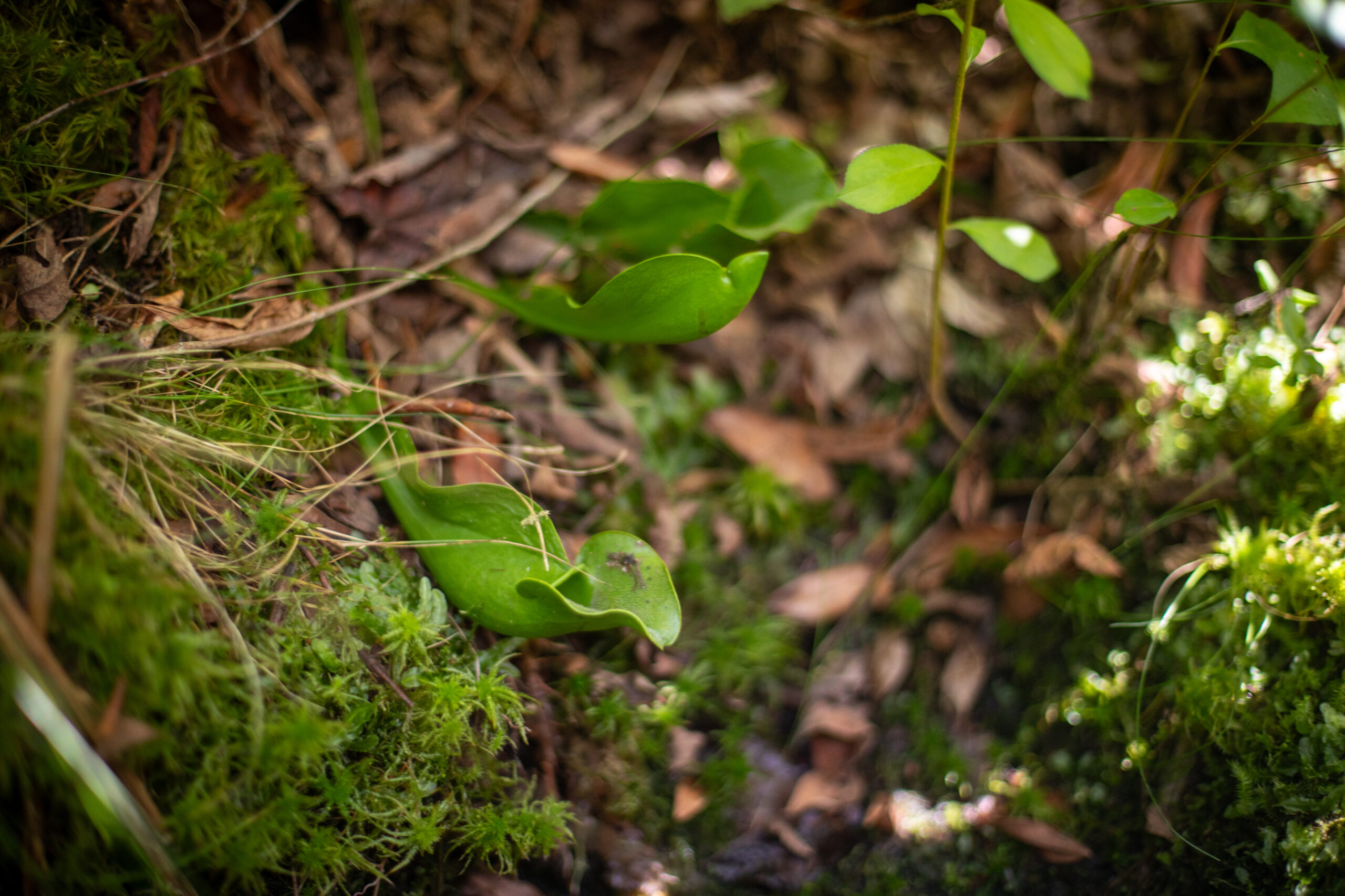
Pitcher plant
Sign Four
As you reach sign four on the boardwalk, you are now entering a series of zones that are unique to bogs. The trees around you are black spruce (Picea mariana) and American larch or tamarack (Larix laricina). Both are conifers—they produce their seeds in cones. Unlike most conifers, however, the larch drops all its needles in the fall.
One of the plants responsible for the physical characteristics of the bog is sphagnum moss (Sphagnum). This moss is also called peat moss because its decayed remains are the chief ingredient of peat (a layer of undecomposed organic plant material.) Sphagnum moss is very spongy and more absorbent than cotton.
As you walk along, look close to the ground for specimens of a remarkable member of the plant kingdom, the insect-eating pitcher plant (Sarracenia purpurea). Like sundews, pitcher plants have evolved to capture insects since peat is low in nutrients. The pitcher-shaped leaves of the plant usually contain water. Insects that enter the pitcher find downward-pointing bristles blocking their exit. Once they fall into the water they drown and are digested by microorganisms living there.
Curiously, some insects live in the pitchers. If you look closely, perhaps you will see wigglers of the pitcher plant mosquito (Wyeomyia smithii).
Swamp loosestrife rerooting at the edge of Pine Hole Pond
Sign Five: Welcome to Pine Hole Pond
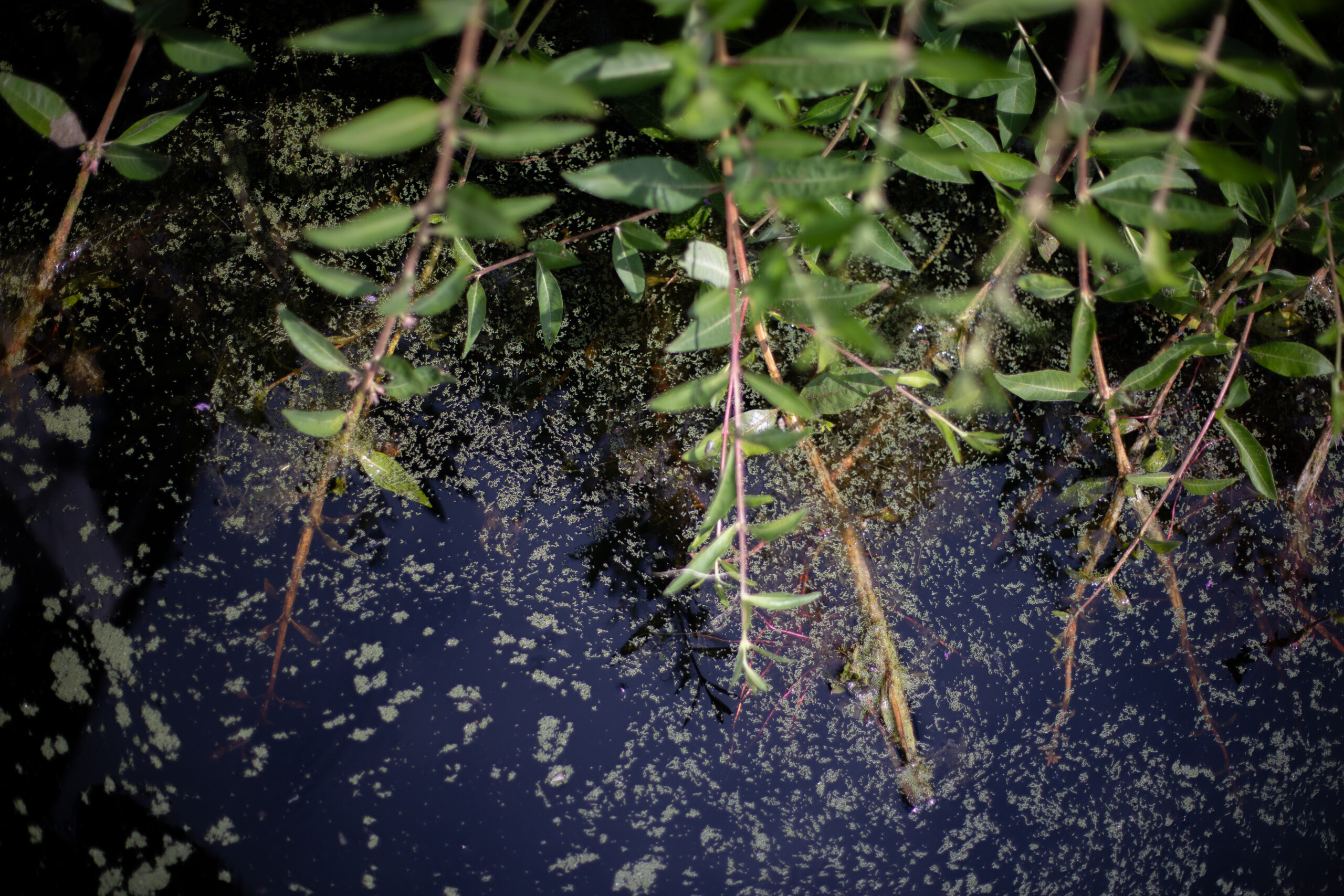
When you reach sign five on the boardwalk, you are standing on a thin mat of tangled vegetation that has grown over and is literally floating on watery muck. If you were to step off the boardwalk (please don’t!) and bounce up and down on this mat, you’d see the trees around you shake—this is why it is called a “quaking bog.”
The low-growing shrub on either side of you is leatherleaf (Chamaedaphne calyculata). It is another member of the heath family, as is sheep laurel (Kalmia angustifolia), which is also growing here. Both plants are evergreen and have thick leathery leaves that help reduce water loss by evaporation. It is something of a puzzle why so many bog inhabitants—living with their roots practically immersed in water—have a feature usually associated with plants growing in excessively dry locations.
Growing in the open water around the outside of the pond is swamp loosestrife (Decodon
verticillatus). Note how it grows in clumps—these clumps provide the first foothold for sphagnum moss and start the formation of the floating mat of vegetation. The stems of the swamp loosestrife arch over the water so that their tips often touch the water. When this occurs, roots develop at the tips and new clumps arise. This allows the mat to slowly grow forward, and the area of open water shrinks. One day, several hundred years from now (it is estimated), the pond will be completely covered.
The water of the open pond does not provide a rich habitat for aquatic life. One reason is that the water is quite acidic. Its pH, a measure of degree of acidity, is 4. This is almost as acidic as orange juice!
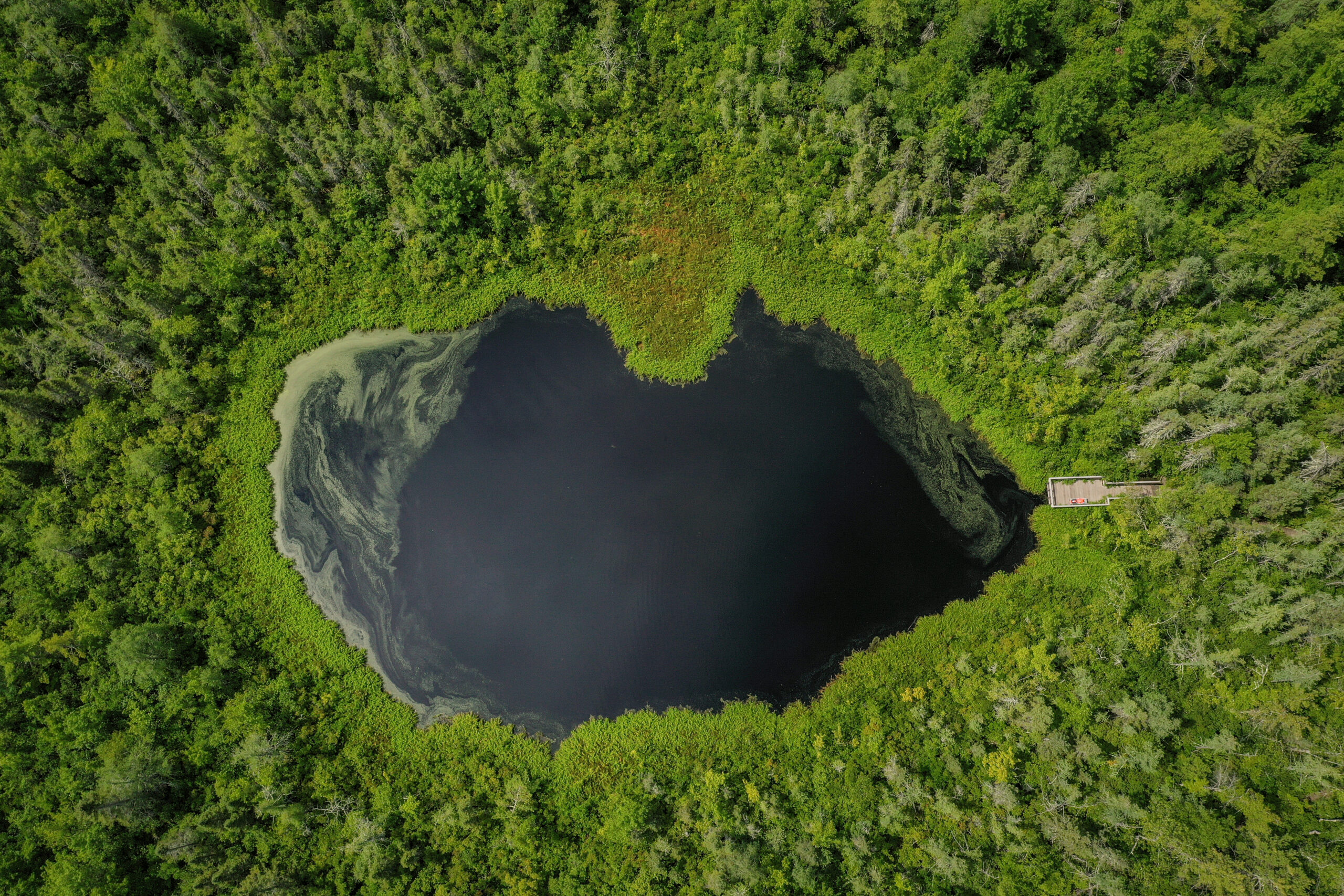
An aerial of Pine Hole Pond
More About the Ecology: How Did This Bog Form?
Bogs share some features with other soggy habitats but also have features that are unique. Just how these peculiar qualities arise is not yet fully understood. By trying to reconstruct the history of the bog, perhaps we can find some clues. Geologists tell us that some 12,000 to 14,000 years ago the most recent glacier to cover New England began to recede. As the southern edge of the glacier melted away, huge blocks of ice occasionally were left buried in the ground. When these blocks melted, deep water-filled basins, which we call glacial kettle holes, were left behind. Such was the origin of this bog. As you approached the boardwalk, you were walking beside the margin of the kettle hole. Lakes and marshes have a one-way flow of water, that is, water flows in one side and drains out the other. In a kettle hole, such as this one, it is more a matter of a basin filling with rain and melting snow, which finally spills over the edges. In fact, the water in this bog spills over into two different watersheds. Drainage to the north eventually reaches Boston Brook, while drainage to the southwest enters the Skug River. With the glacier gone, plant life began to recolonize the landscape. Aquatic plants began growing in the kettle hole. As they died, their remains began to accumulate along with plant debris such as pollen and leaves blown in from surrounding areas.
Decay in a bog is extremely slow. The stagnant water is deficient in oxygen, thus inhibiting the development of the microorganisms responsible for decay. The low temperatures of the bog also inhibit decay. The natural depression of this bog forms a frost pocket. Furthermore, the peat of the bog is a good insulator and warms up very slowly in the spring. For example, on April 15, 1969, six days after the ice had melted, the soil temperatures in the bog averaged 40°F, 10°F below those on the upland areas surrounding the bog. The plants in the bog are correspondingly delayed in resuming their growth in the spring. The needles on the tamaracks on the upland areas nearby had grown to half an inch by April 20, 1969, while in the bog, growth was just beginning. Not until May 15, 25 days later, did the needles on the bog tamaracks reach a length of half an inch.
With a shortened growing season in the bog, it is perhaps not surprising to find species, such as the black spruce, that now live chiefly at higher latitudes. These plants are probably the descendants of species that grew throughout this area in early post-glacial times but were eventually supplanted as the climate got warmer. In the bog, however, they have been able to survive. Curiously enough, these relics of the Ice Age share the bog with a number of plant species of southern origins. The pitcher plant and sundew, as well as several members of the orchid family that grow in the bog, are examples.
What possible explanation could there be for such an association of northern and southern species? Plants living in the coniferous forest of the north and in the rain forest of the tropics do share one problem. In both locations, the soil is deficient in minerals and often soggy. With its granite rocks and abundant rainfall, New England does not have soils that are very fertile either. The situation is especially severe in the bog because what minerals do wash in, are quickly absorbed by the organic matter, chiefly peat, and become inaccessible to the plants. With the abundance of organic matter, one might expect nitrogen, at least, to be plentiful — but such is not the case. The microorganisms responsible for the release and recycling of nitrogen from dead plant material are unable to function effectively under acid conditions and with the low levels of oxygen available. The severe shortage of nitrogen in the bog may perhaps account for the insect-eating plants found here. By digesting insects that enter their traps, both the pitcher plant and sundew acquire nitrogen compounds for their own growth. With dead plant remains accumulating faster than they decay, a thick deposit of organic matter has formed in the bog. In some parts of the world, such bog deposits are removed, dried, and used as a fuel — peat. Peat represents the first stage in the formation of coal. Peat deposits such as this one have also produced a great deal of information about fluctuations in climate and surrounding plant communities in the past. Boring into the layers of peat reveals pollen grains and other ancient plant remains in remarkably well-preserved condition. Scientists studying such peat samples have been able to reconstruct detailed histories of bogs such as this one. Although no boring has been done on this bog, you can recreate some of its history as you retrace your steps along the boardwalk.
In front of you is an area of open water, the last remnant of a pond that once extended all the way to the start of the boardwalk. Surrounding this is a zone of plants that can grow right in the water, and which provide a foothold for hardy species such as leatherleaf and sphagnum moss. Their growth provides, in turn, sufficient support for such northern-type conifers as the black spruce and tamarack. With the mat growing thicker, red maples, alders, and blueberries became the dominant species. Even some white pines have begun to grow in the bog, although most of them die at a relatively young age. Thus, as you walk from the water’s edge back to dry land, you pass through distinct plant communities. These recreate in space the sequence of events that have taken place in time during the inexorable process of filling in the bog. Such a sequence, in which the development of one plant community sets the stage for its own replacement by another, is known as succession. Although succession has been occurring in this location for more than 10,000 years, the process is not yet over. How many more years will it be before the open water, sphagnum moss, pitcher plants, and black spruces have disappeared, and a red maple forest is all that remains?